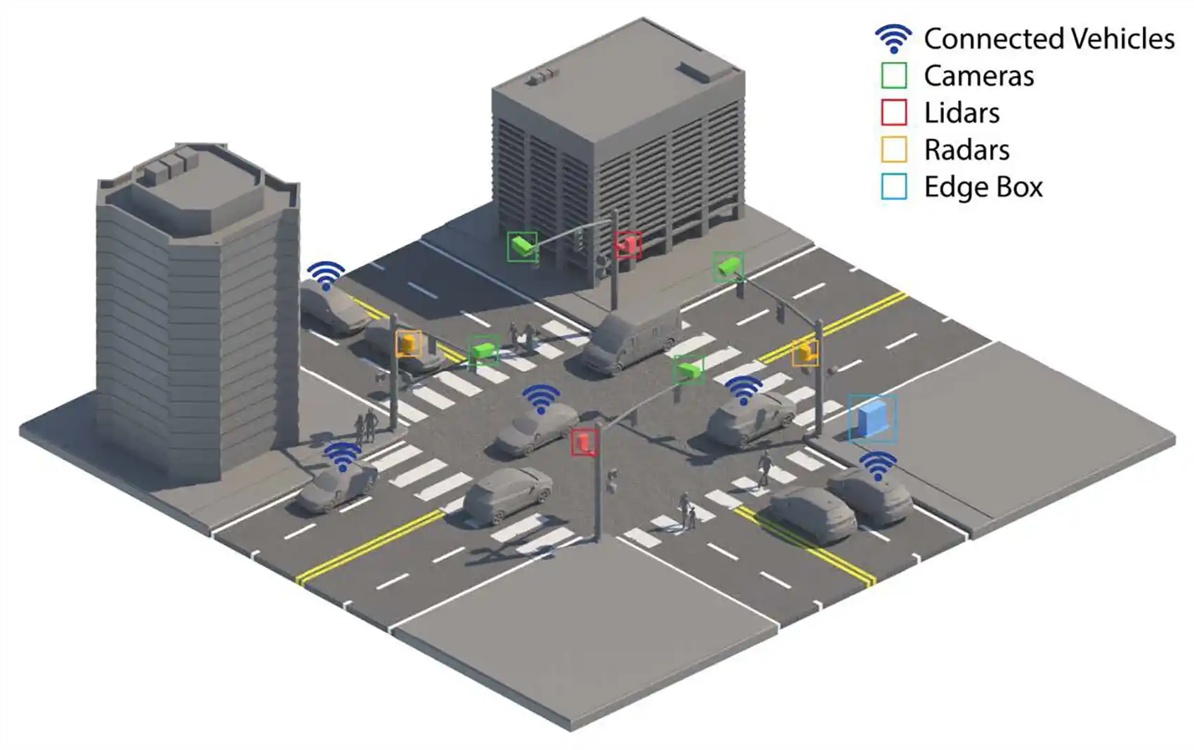
Researchers at the National Laboratory of the Rockies are deploying multisensor data fusion technology to optimize traffic flow and reduce intersection collisions through real-time digital monitoring systems.
The team has developed a digital-twin framework that creates a live computational model of traffic conditions at intersections. This system integrates data from cameras, radar, lidar, and vehicle-to-infrastructure communication to generate millisecond-level visibility into vehicle movements and pedestrian activity. The approach addresses two recurring urban problems: inefficient signal timing that leaves drivers idling at empty intersections, and collision risk from signal violations.
Current traffic management infrastructure relies on fixed signal timing or basic loop detectors buried beneath roadways. These systems cannot adapt to dynamic conditions like unexpected congestion, weather events, or pedestrian patterns. The NLR framework continuously processes incoming sensor streams to adjust signal timing in real time, reducing unnecessary stops and accelerating traffic flow.
The digital twin creates a virtual replica of physical intersections. Machine learning models trained on historical data predict vehicle arrivals and optimize green light duration before vehicles reach the intersection. Early results from pilot deployments show measurable reductions in average delay time per vehicle and total emissions from idling and acceleration cycles. One test site reported a 12 percent reduction in intersection delay and corresponding fuel consumption savings.
Safety benefits compound the efficiency gains. The system detects red-light runners before collisions occur, alerting nearby drivers and adjusting downstream signal timing to create buffer zones. Pedestrian detection algorithms flag high-risk crossing scenarios and can override signal cycles if a child or elderly person enters the intersection during the wrong phase. Vehicle-to-infrastructure communication allows connected vehicles to receive real-time warnings about collision hazards.
The technology has cost implications for municipalities. Installation requires initial hardware investment in sensors, computing edge devices, and connectivity infrastructure. However, reduced congestion lowers vehicle operating costs for drivers through decreased fuel consumption and brake wear. Emergency response times improve because fire trucks and ambulances encounter fewer traffic delays. One analysis projected annual savings of $2,400 per intersection when accounting for fuel economy and reduced accident response costs.
Scaling remains a challenge. Most U.S. intersections lack the sensor infrastructure or communication networks required for this system. Retrofitting 300,000 traffic signals nationwide would cost billions in capital and ongoing maintenance. Privacy concerns arise from continuous video monitoring, though researchers note that the system can process video locally on edge hardware without storing raw footage or identifying individuals.
The NLR team is currently testing the framework in partnerships with transportation departments in Colorado and Wyoming. Findings will inform deployment guidelines for other municipalities considering adoption. Federal funding through the U.S. Department of Transportation has supported development phases, and the research aligns with the Biden administration's infrastructure goals to modernize transportation networks while reducing carbon emissions from vehicles.
The intersection represents a critical node in urban transportation systems. Optimizing just these points ripples across entire traffic networks, reducing congestion-related emissions and improving safety outcomes without requiring vehicle electrification or behavioral change from drivers.