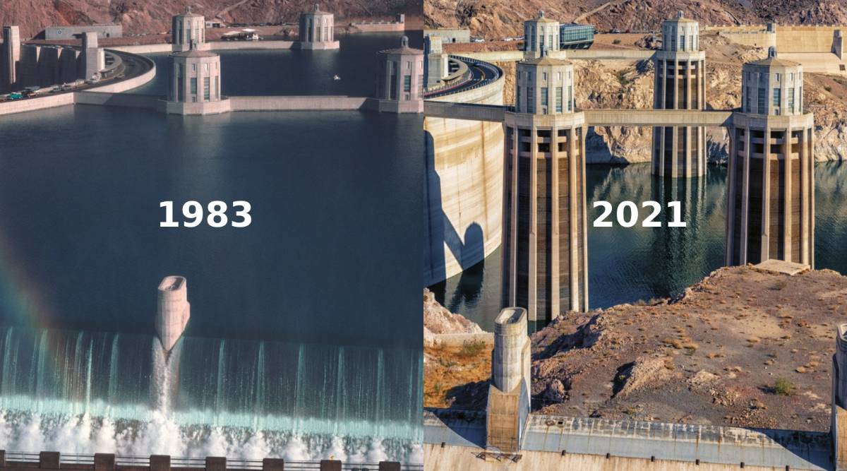
# Water Crisis in the American Southwest Threatens Regional Stability
The Colorado River supplies water to seven western states facing an unprecedented scarcity crisis that threatens agriculture, cities, and power generation across the region. Arizona, California, Nevada, Colorado, New Mexico, Utah, and Wyoming depend on a water allocation system designed in 1922 for a wetter climate that no longer exists.
The 1922 Colorado River Compact divided water rights between upper basin states (Colorado, New Mexico, Utah, Wyoming) and lower basin states (Arizona, Nevada, California). The agreement allocated 7.5 million acre-feet annually to each basin, totaling 15 million acre-feet. This allocation assumed average annual flows of 16.5 million acre-feet, a figure derived from an exceptionally wet 16-year period in the early 1900s.
Current reality diverges sharply from these assumptions. The Colorado River now delivers approximately 12.4 million acre-feet annually on average, according to U.S. Bureau of Reclamation data. Lake Mead and Lake Powell, the two largest reservoirs storing Colorado River water, have fallen to historic lows. Lake Mead sits below 27 percent capacity. Lake Powell operates at approximately 25 percent capacity. These declines trigger mandatory water cuts under the Colorado River Interim Guidelines established in 2007.
Arizona faces the steepest cuts, losing 21 percent of its allocation by 2025. Nevada loses 25 percent. California retains priority access but faces pressure to reduce consumption. Agriculture absorbs roughly 80 percent of Colorado River water, primarily in California's Imperial Valley and Arizona's Pinal County. Cities including Phoenix, Las Vegas, and Los Angeles compete with farms for diminishing supplies.
Drought intensified by climate change drives much of the crisis. The Southwest experienced a 22-year megadrought beginning in 2000, the driest period in 1,200 years according to research published in Nature Climate Reports. Rising temperatures increase evaporation from reservoirs and reduce snowpack in the Rocky Mountains, which feeds the Colorado River during spring runoff. Since 2000, declining snowpack has reduced river flows by approximately 1.8 million acre-feet annually.
The region's power generation capacity hangs in the balance. Lake Mead supplies water for hydroelectric generation at Hoover Dam, producing 4,000 megawatts of capacity. Declining reservoir levels force the dam to operate at reduced power output. Lake Powell supplies Glen Canyon Dam, generating 1,270 megawatts. As water levels drop, both facilities produce less electricity, forcing utilities to replace hydropower with natural gas and other sources.
States and federal agencies negotiate to prevent total system collapse. The Lower Basin states reached a drought contingency plan in 2019 requiring additional voluntary cuts. In 2023, the U.S. Department of Interior mandated even steeper reductions. These agreements attempt to maintain minimum levels in Lake Powell required for hydroelectric generation and minimum flows to Mexico under a 1944 treaty.
Without aggressive action, experts warn the Colorado River system could reach "dead pool" status where water no longer flows between states. Arizona officials report that some rural groundwater supplies face exhaustion. The region's 40 million residents and $5.5 trillion in regional economic output depend on continuing Colorado River flows that existing agreements assume will be larger than current hydrology allows.
Negotiations for post-2026 Colorado River management have begun. States and tribes face difficult choices between protecting agriculture, cities, and Mexico's water rights while adapting to a drier climate.