Laser-equipped aircraft are documenting unprecedented snowpack losses across western U.S. mountains, revealing conditions far more dire than visible to the naked eye.
The Airborne Snow Observatories operate specialized aircraft equipped with lidar sensors that measure snow depth and water content with precision unavailable through ground stations or traditional satellite imagery. Tom Painter, CEO of the organization, characterizes current conditions as "a distinct dry year," signaling alarm among water security experts.
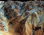
The Sierra Nevada mountains exemplify the crisis. While snow appears adequate from the air, the lidar data tells a different story. The sensors detect critically low water content locked in the snowpack, threatening water supplies for millions of Californians and other western states dependent on spring snowmelt for agriculture, municipal systems, and hydropower generation.
This technology addresses a fundamental blind spot in water resource management. Ground-based snow measurement stations remain sparse across remote alpine terrain, leaving officials to estimate conditions from incomplete data. Satellite imagery cannot penetrate cloud cover or distinguish between old, dense snow and fresh powder. Lidar solves this by measuring snow depth across vast areas with meter-scale resolution, then calculating water equivalent using the snow's density profile.
The implications ripple across western infrastructure. California's State Water Project and federal Bureau of Reclamation rely on April 1 snowpack measurements to forecast water availability for the entire year. If this winter's accumulation falls short, water allocations to farms, cities, and environmental flows face severe cuts.
Climate change amplifies the problem. Warming temperatures shift precipitation from snow to rain at higher elevations and accelerate spring melt, compressing the reliable water supply window. Multiple dry years in succession, as documented by these aerial missions, deplete mountain snowpack reserves that normally carry water supplies through summer drought.
The Airborne Snow Observatories data provides the early warning system water managers desperately need